This website is all about Hatley St George and East Hatley, with news, history, community updates, details of local services and other things we think may be helpful.
Hatley’s grid references are:
TL 28257 50876
Latitude 52.141293
Longitude -0.127223
The parish of Hatley unites Hatley St George and East Hatley, two very small villages half a mile apart in the arable farmland of south Cambridgeshire. Although quite a few of us work from home, we are largely a commuting population, albeit with a strong sense of community.
There is more about the history of the Hatleys on our Hatley history page – and photographs of Hatley and the surrounding area on the Geograph site. (The Geograph Britain and Ireland project is collecting geographically representative photographs and information for every square kilometre of Great Britain and Ireland from material supplied by, well, anyone.)
If you’re interested in the geology of Hatley, the wonderful British Geological Survey website is the place to go – www.bgs.ac.uk > data > view maps.
Pre-Domesday
There is another Hatley near by – Cockayne Hatley, which is in Bedfordshire (we’re in Cambridgeshire) and historically not connected to ‘our’ Hatley.

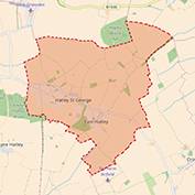
The modern day (2017) civil parish boundary of Hatley. Click on the map (and the pictures below) for larger versions.
The extent of the parish is shown on this map; its Parish Council was established on 5th July 1973.
Hatley is roughly halfway between Bedford and Cambridge, linked by footpaths and bridleways to the surrounding villages.
The two villages predate Domesday. They share two medieval churches, a village hall, a playing field with swings and a village shop-cum-post office.
There’s a useful, and up-to-date, section on Hatley on the Wikipedia website. Details of the listed buildings in Hatley can be found on the British Listed Buildings website.
Hatley is also listed in the Open Domesday project, which shows there were 32 households in East Hatley and Hatley St George in 1066 – the 2011 census puts the figure at 78 (click on the ‘census’ link above to open an Excel file – use the drop down list to find Hatley).
Moats
A feature of the Hatleys is the more important buildings were once surrounded by moats. These can still be seen, especially in East Hatley.
Next to a good water-supply, a dry soil for building was generally essential, though some west Cambridgeshire villages planted upon heavy ill-drained clays put a moat around every house to drain the site, as at East Hatley, where most of the moats, or the remains of them, can be traced to this day. From English Landscapes by W G Hoskins, BBC Publications, 1973 (ISBN 0563 12407 5).
Professor W G Hoskins (1908-1992) is credited with establishing English local history as a formal academic discipline. His pioneering book The Making of the English Landscape, first published in 1955 (ISBN 0140154108), is well worth reading, although currently out of print – second hand copies can be obtained via Amazon, second-hand booksellers, antiques shop / centre or charity shops. Don’t be put off by not being able to get the 1955 edition – it has been republished several times, notably by Penguin and the Folio Society, often with a new introduction either by Hoskins or a modern-day ‘editor’ who adds their own commentary, usually noting the considerable advances in landscape research over the last 60+ years.
Churches
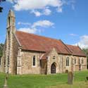
The Grade II* listed parish church of Hatley St George (left) stands opposite St George’s Tower, originally a water tower, now part of a small business park.
Services are held monthly. While usually referred to as ‘Hatley St George church’, its official name is ‘Chapel of St James the Greater’ – and not, as it may seem, ‘St George’ (which refers to the St. George family who gave their name to the village in the 14th century).
The church also has two special features: no chancel (the area with the altar and where the choir would sit – it was demolished in 1966) and 28 wooden shields painted with the arms of the St. George and Cotton families.
The church is normally locked – the key can be obtained from the farmhouse opposite.
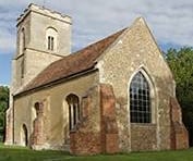
St Denis’ church in East Hatley (below) is also Grade II* listed – but is now an empty shell and no longer in use – you can visit it at any time, for it is open daily (from 8.30 am to dusk) for quiet contemplation or just to look round.

St Denis’ church East Hatley. It is open daily (from 8.30 am to dusk) for quiet contemplation or just to look round.
Although essentially a medieval building (as it still is), it was restored in 1874 by William Butterfield, the notable Victorian church architect who reroofed it, kept the nave much as it always had been (and reused the medieval roof timers to support a new floor), but added a new chancel, decorating it with a restrained version of the polychromatic detailing for which he was famous in his day.
We are very fortunate the Friends of Friendless Churches (FoFC) was able to take ownership of the building in November 2016 – albeit structurally sound but windowless, with much of its floor missing, its chancel in a poor state and, worse, without an obvious future.
In early 2018 the FoFC made a great start on its programme of repairs by putting a new floor and windows in the nave, following this up in 2021 with new windows in the chancel (one incorporating stained glass from the old east window) and consolidation of the plasterwork in the chancel.
In May 2022 the final major restoration project was completed with new plasterwork in the nave replacing the very crumbly old plaster. The church is open every day from around 8.30 am to dusk to look round or for quiet contemplation.
This only leaves one special funding requirement – for a new east window: donations, please, to the FoFC.
Its churchyard, however, is still consecrated and is a Local Nature Reserve – it retains its moat; other moats can be seen from the road near Manor Barn and The Palace.
Use this link for much more on Hatley’s two churches.
Footpaths, bridleways and other useful information
There are lots of footpaths and bridleways around East Hatley and Hatley St George, well noted on Ordnance Survey maps – and these right of way definitive maps.
The same goes for the Green spaces and activities section of the Cambridgeshire County Council website – the link above takes you to the Definitive map and statement page (with useful background information) from where you can click on the Rights of way interactive map for the county.
Put your postcode into the search box on that page to home in on Hatley: click on a footpath or bridleway for its name, number and length – with much more detail for bridleways.
And while on this section of the County’s website, click on the My house tab for lots of useful local information.
Historian and former Gamlingay resident Bernard O’Connor has some very detailed information about the Hatley footpaths (as well as those in Gamlingay and other local villages).
For Hatley, use this footpath link and then click on the individual footpath numbers. For other villages, use this link and click on the village name.
There is more about Hatley St George and East Hatley on the Wikipedia website.
First published on the original Hatley website, May 2013; added to this website, 2018 – links checked / page updated 28th October 2022.


